Tuesday, February 27, 2007

Day 19 - Joplin to Home Sweet Home

After working all day in Missouri, it was time to hit the road again and head for home. I took this quick shot of the St. Louis Arch by hanging my arm out the window while driving across an expressway bridge over the Mississippi river!


I finally got home close to midnight to barrel the car and trailer head first into my snow filled driveway. Ugh, home sweet home.... no more sunny beaches, no more beautiful national parks, no more fun Route 66 attractions. Just cold and snow. When do we leave on our next trip?

In the end, Millie and I logged 5900 miles in 19 days and saw 8 states. The Route 66 drive was not the nostalgic 1950's rose-colored glasses tour of Americana that the guidebooks promised, but a long, large journey of extreme contrasts-- deserts to farmlands, mountains to plains, the vibrant small towns where folks still hang their laundry outside on a clothesline in the afternoon and visit with neighbors from their front porch swing, contrasted to the decaying ghost towns filled with rusting thrown-away junk of a past generation; the affluent suburbanites with their strip malls and big box stores gobbling up and demolishing the historic old Route 66 landmarks in their path, contrasted to the forgotten homeless and working poor living in crumbling, dingy, converted motel apartments wondering where their next meal will come from. It was indeed hard to imagine that all of this could be the real America.

I can't imagine what this journey must have been like for our parents and grandparents in the 20's, 30's, 40's or even the 50's-- traveling in all the comforts of a non-air conditioned, non-power anything, non-cruise control car and wondering what kind of gas, food, and lodging loomed over the horizon in the pre-internet, pre-chainstore days. But, even with all of today's creature comforts, the trip is still a bona-fide adventure... with miles and miles to ponder what was, what is, and what might be America.

Monday, February 26, 2007

Day 18 - Amarillo to Joplin

After working Sunday evening and most of Monday at the KOA in Amarillo, I hit the road again in the afternoon to drive to Joplin, MO catching some of the east Texas panhandle sights that I'd missed on the way out due to the foggy icestorm.

The little town of McLean, Texas was a major gas stop in the early Route 66 days. Lots of old gas stations in town, including this restored gem--- the original Phillips 66 station for the state of Texas. Since my friend Natalie's husband works for Conoco-Phillips, I thought they'd enjoy these shots!


Not to be outdone by the restored Phillips station, this is the beautifully restored Conoco station in Shamrock, TX:


I didn't have time to stop, but this National Route 66 Museum in Elk City, OK looked like a very interesting place!


And, what a way to end the day, with yet one more T@B gawker... this time a bovine!

Sunday, February 25, 2007

Day 17 - Holbrook to Amarillo

I had wanted to stay in different towns on the way back home, but it just didn't work out that way. So I stayed at KOAs again where I knew I'd get good wifi coverage.

As I left Holbrook, I just couldn't resist this real "Cars"-looking tow truck.

I also made a quick stop at the Painted Desert again in Petrified Forest National Park. Afterwards, it was time to put the camera away, and head for Amarillo.

Saturday, February 24, 2007

Day 16 - Barstow to Holbrook

There was a large billboard sign welcoming me to Barstow, California, the "Gateway to Opportunity". Well, it's a gateway alright. But opportunity seemed a little questionable to me. I stopped at the McDonalds in town only to discover that it was a major bus stop for tour buses. About 20 of them had stopped to let their 1500 or so passengers try and all use the restrooms and order breakfast at the same time. What a zoo! Most passengers looked like poor inner-city hispanics and african-americans on their way to Vegas for the day hoping to better their luck.

As I drove out of the parking lot, I noticed a bearded man wearing an Army camouflage jacket digging through a McDonalds trash can. He discovered a half-eaten Egg McMuffin and devoured it in a few quick bites. I sure hoped to God he wasn't a war vet. How incredibly sad.

I was happy to finally leave the Gateway of Opportunity and get to drive the longest stretches of remaining original Route 66--- the drive from Newberry Springs, CA to Kingman, AZ. A couple hundred miles of pure 66. This sign on the road in the Mohave desert even proves it!

Here's the Bagdad Cafe of movie fame:


Along with another big 66 landmark, Roy's Motel and Cafe in Amboy, CA.

I watched a freight train travel along side of me for about 30 minutes through the Mohave desert, until the tracks passed over Route 66 and forced me to stop. Nothing else to do but take a picture!

The weirdest rocks I saw were also in the Mohave desert. These looked like chunks of torn up asphalt roadway, but they were actual black rocks, rather porous in texture, and almost volcanic looking. I had to laugh when I spotted this Century 21 sign in the middle of absolute nowhere out in the desert. It had to be a joke!

After stopping for lunch in Needles, CA, we crossed over the border back into Arizona for what was undoubtedly the most fun stretch of old route 66 for the entire 6000 miles! It was about a 90 mile segment from the border to Kingman, and it travels up over 3000 feet through a mountain pass.

Without a doubt, my favorite Route 66 town was Oatman, Arizona, an old restored gold-mining village where 66 becomes incredibly narrow with buildings edging the roadway and scads of tourists walking in the road. I was stopped for about 10 minutes waiting for a mock Cowboy gunfight to finish up. Then, as I inched my way through town, I was stopped again by....

an ASS IN THE ROAD! Well, actually, an adorable little white burro. Oatman has a dozen or so of these "wild" burros that roam through town being fed carrots and who knows what else all day long by the tourists. These little guys got it made!


East of Oatman, Route 66 hugs the moutainsides as it makes it's way up to the pass. It was a really fun drive.

On the other side of the pass, is a cute little restored gas station called Cool Springs, owned by a real estate man from Chicago. A neat retired lady was running the store and asked me to come inside after I shot my pictures. I was thinking she wanted me to come buy something in return for the pictures, but she actually wanted to find out more information about my trailer! Turns out, she and her husband used to RV with a big 5th wheel, but he died a few years ago and she hadn't been RV'ing since. But seeing my little trailer made her feel that she could easily manage something that size on her own. I took her out and let her look inside the trailer and gave her T@B's website address. She was so excited! My little T@B seemed to be opening the door up for her again to explore the country and get back to RV'ing. It's so fun to have a trailer that does that for people!

After getting to Kingman, I decided to continue on another 90 miles of old Route 66 to Seligman, Arizona. This stretch wasn't nearly as fun as the previous one, but it still had a few neat things to see like this old car with a sign that pointed to both LA and Chicago, and the old truck next to it.

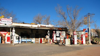
And this neat old gas station in Hackberry:

As the sun began to set, a straight stretch of native 66 made the perfect photo to cap off a really fun day.


Friday, February 23, 2007

Day 15 - Morro Bay to Barstow

Our week in Morro Bay went by far too quickly and it was now time for us to pack up and start the long drive home. I finished up work Friday afternoon so that we could drive down the coast while it was still daylight.

I had considered spending the week in the Santa Barbara or Pismo Beach areas before I settled on Morro Bay, and was so glad I didn't! Pismo seemed rather seedy to me, and most of the Santa Barbara beach scenes were ruined by dozens of offshore oil rigs dotting the horizon. Additionally, traffic was a mess down there!

Millie and I stopped in Malibu just as the sun was setting. Millie got to do one final run on the beach and pretend to be a blonde bimbo Malibu girl....

While I admired our little Malibu beach house!


The rest of the evening was numbingly frustrating as I stupidly drove through L.A. during Friday night rush hour(s). It was still bumper-to-bumper as late as 9:00pm nearly all the way out to Barstow!

Thursday, February 22, 2007

Day 14 - Morro Bay

It had poured rain all day, but then miraculously, the sun came out around 4pm just as I was finishing up work, so I grabbed my camera case and headed back down to Montana de Oro State Park. This was the same beach as I had shot a few nights before, but this time I was up on a bluff overlooking it. Gorgeous light peeked through the clouds.

But, the sunshine was short-lived. A few minutes later, I looked out to the ocean to see another storm front approaching. By the time I stopped at Morro harbor for dinner, it was pouring down rain again, so I decided to work the rest of the evening.

Wednesday, February 21, 2007

Day 13 - Morro Bay

Today was mostly cloudy all day. After work, I took Millie to a dog park in San Luis Obispo where she got to play with a dozen other dogs of various shapes and sizes. As we drove home, the clouds started to break ever so slightly, so we high tailed to our beach for the sunset. And what a glorious sunset it was!


Millie and Morro Rock:

Tuesday, February 20, 2007

Day 12 - Morro Bay

I just love the central coast! It doesn't have the traffic jams and big cities of the north and south, has a bit of both kinds of beaches (rocky and sandy), has gorgeous green grassy hills, and is easily accessible to the wineries of Paso Robles, Hearst Castle, San Luis Obispo, the boat harbor of Morro Bay, and cute little artist villages like Cambria.

For tonight's sunset photo opp, I drove up to the Hearst Castle area to "seal beach". One of the rangers at Yosemite recommended it and said the seals were beached there this time of year having their babies. Well, I didn't see any babies, but found literally hundreds of elephant seals.

The males are enormous, some as big as 15 feet in length and weighing up to 2000 pounds. They also have a distinctive "trunk" nose that they grunt through to swoon the ladies. It was fascinating to watch them for an hour or so!


Monday, February 19, 2007

Day 11 - Paso Robles to Morro Bay

In the morning, I made the quick drive over to the coast to begin my California work week at Morro Bay. The park had excellent wifi, so I was even able to work from my lounge chair outside (that's my laptop on the chair!).

A really nice thing about working in California was that if I did my workday on Central or Eastern time, I could be done in time for a couple hours of sunset shooting each day! My RV park was only 1 block from a terrific sandy beach called the Strand, on the northside of Morro rock. It was also a dog beach, so Millie was in absolute 7th heaven!

Just south of Morro Bay, we found another gorgeous dog beach at Montana de Oro State Park. After watching the sunset, Millie got chased around a bit by a chocolate lab named Buddy. She's such a tease!

Sunday, February 18, 2007

Day 10 - Yosemite to Paso Robles

I stopped by the Ansel Adams Gallery on my way out of the valley. The cashier was saying that it had been one of the warmest weekends ever for February (in the low 60's during the day), but that there was a chance of snow that night. Ah, too late for me though. I needed to leave for the coast where I'd be working all week. Unfortunately, no good wifi coverage or electric hookups in Yosemite Valley!

Well, not 10 minutes after I started driving out of the valley, it began to rain and didn't stop the rest of the day. That made me feel a little better about this being my driving day.

I spent the night at a ritzy upscale RV resort in the wine country of Paso Robles. Everyone in the park had big motorhomes or 5th Wheels, except for me and my little T@B! They had a nice fenced-in dog area where Millie could finally run with her leash off. She instantly made friends with a bulldog named Dolly Madison as I chatted with Dolly's owner and another guy who had just moved back to the mainland from Hawaii. One way to feel like a hot young thing is to hang out at ritzy RV parks. I think I was the youngest single female there!

Saturday, February 17, 2007

Day 9 - Yosemite

I started out the morning by driving up to the northern part of the park as it was one area I didn't get to see during my last trip. The Hetch Hetchy Reservoir is part of Yosemite and a real power-producing hydro dam. The environmentalists of the early 1900's fiercely fought to protect this valley from damming, calling it the "little Yosemite valley", however, they weren't able to stop the project. Today, the area is not heavily visited due to 9/11 restrictions that curtail access except for viewing and picnicing during the day. But it is a gorgeous place, and really makes you wonder what got hidden beneath all that water.

Why oh why did I not pull out my infrared camera earlier? It does an amazing job with some of these classic Yosemite scenes--

The overlook as you first enter the valley from the southern access road showing El Capitan on the left, Bridalveil Falls on the right, and Half Moon back in the distance in the center.


The same scene from the valley floor with the Merced river in the foreground:


And my favorite scene of Bridalveil Falls:

For sunset this evening, I decided on the view of Half Moon with a reflection from the Merced river. This time, I was only joined by about 15 other photographers!

Friday, February 16, 2007

Day 8 - Yosemite National Park

When I first saw Yosemite valley eight years ago, I thought it was the most impressive, power-packed 20 square miles of land in the whole national park system. Since then, I've seen some other pretty amazing parks-- Yellowstone, Denali, the Grand Canyon. But still nothing compares to Yosemite Valley. Above, is the tallest waterfall in the United States, Yosemite Falls.


I had wanted to come to Yosemite in mid-February for two reasons-- first, to try and photograph the valley in winter (didn't happen), and second, to catch a once-a-year phenomenon called a "Firefall" off the edge of El Capitan.

As the sun sets on El Capitan in mid-February, it's positioned in such a way to shed light onto a small waterfall. I had read a magazine article about it a few months ago and recalled the author saying you'd find the spot by looking for a small parking lot jammed with cars that seem to be there for no good reason (no visual landmarks nearby). Well, he was precisely correct. I got there about a 1/2 hour before sunset, and had to park at another small lot a few yards up the road because the little lot was already full with photographers' cars! At the height of activity, there were probably 30 or so photographers all shooting this. With our tripods and telephoto lenses, we must have looked like we were the press pool for the Super Bowl! But it was lots of fun to chat, and all "ooo and ahh" together as the mist lit up off the waterfall.

Initially, the fall looked like a nice normal waterfall and sunset:

But as the sun continued to set, the light became a more narrow vertical strip along the face of the mountain, until it only illuminated the waterfall and the mist itself. One of the most amazing things I'd ever seen. Quite spectacular!


Thursday, February 15, 2007

Day 7 - Death Valley to Yosemite

For my last morning in Death Valley, I decided to catch the sunrise on Zabriskie Point.

The previous afternoon, I had taken a fun little 4WD road called the 20 Mule Team Trail, so decided to drive it once more. I'm not sure what the rocks are, but they leave a chalky dust around them, and when you're driving in between these little hills you really do get the feeling you're on another planet. Nothing looks earth-like here!


After that fun drive, I went back to the campground to hook up the T@B and start my drive out to Yosemite. To get out of Death Valley, on either side, requires a 4000 foot climb out of the valley. On the west side, the climb is straight and uphill. They position these large tanks of "radiator water" every few miles. I'd never want to be here in the 120-degree summer heat!

I thought alot about pioneers trying to cross these valleys on their way to the California gold rush country on the other side of Yosemite. If they somehow managed to drive their horse-drawn wagons across the hot, dry Nevada desert, and then through the torturous heat and elevation changes of Death Valley, can you imagine their utter hopelessness of finally surviving and crawling out from Death Valley only to see this? (the 14,000 foot Sierra Nevada range!). I honestly don't know how they did it.

Since the Sierras were still filled with snow, I had to drive south and around them to get to Yosemite-- down through the Mohave desert and up the San Joaquin Valley through Bakersfield and Fresno.

The final drive out of the Mohave desert just east of Bakersfield was interesting. On one pass is a giant wind power plant (dozens of large windmills). It's very cool to see some new alternative power plants being built. It apparently was positioned on the last of the "arid" hills, because as soon as I went over them, the landscape suddenly changed to lush green grassy hills. Very weird.

The San Joaquin was busy as usually with it's endless line of semi trucks hauling fruit and vegetables, and almost half the radio stations were all in Spanish!

I finally reached the entrance to the south end of Yosemite as the sun was setting. On the park brochure was a piece of paper stapled on warning that all drivers were required to carry snow chains with them in the park. Yikes! I didn't have any. But crossed my fingers that the weather would be warm as forecasted. Fortunately, it was.

One nice thing about camping at Yosemite in the off season--- you easily get spots at the primo campground in the Valley itself. Here's the T@B at Upper Pines campground, a gorgeous place.


Wednesday, February 14, 2007

Day 6 - Death Valley National Park

Unlike other National Parks, Death Valley is not a place for the casual passer-by tourist out for a pleasant drive for the day. It takes real effort to get here, and to stay and survive here. But still, for all of it's hostility in the summer, it's a fascinating place and quite pleasant to live in during winter months. This stretch of road above is actually over 200 feet below sea level. At one of the stops, there's a small sign about halfway up one of those hills that marks where sea level actually is.

Much of the southern valley was once a giant inland sea. What remains there now is a salt flat that stretches for about 100 miles. This picture was taken directly above the road picture from a spot 5000 feet above the valley called Dante's View:

The landscape appears quite desolate, but it's actually quite varied up close. It still, however, gives you the feeling of being on the Moon or Mars in places. Here's one of the spots on the Artist's Palette drive where Millie got to take a little walk


But lest you think Death Valley is totally a harsh desert environment, here's a surprise. Right in the middle is an oasis of palm trees and even a lush green golf course known as Furnace Creek. These developments have been here since the 20's long before this was a National Park, so they got grandfathered in. Here is the posh Furnace Creek Inn (rooms about $400 a night!):


Even at my far more humble campground ($18 a night!), there were a few trees sipping the water from the Furnace Creek water supply. I stopped back at my camper at high noon and thought it'd make a terrific infrared shot--


So while much of Death Valley is famous for it's dried mud flats and arid conditions:


There are some plants and wildflowers that manage to survive and flourish in the middle of this

I really wished I had more time here than what I had planned for. There were vast areas of the park I never made it to, so this is certainly on my list of places to visit again....even though it's nearly impossible to get to!

As sunset approached, I was torn by having to decide on just one place to photograph. I decided to shoot the dunes near Stovepipe Wells... and loved every minute of it!


Tuesday, February 13, 2007

Day 5 - Kingman to Death Valley

Millie and I spent the night at a KOA in Kingman, Arizona. This was Millie's second night at an Arizona KOA and she was not too happy about the desert doggie bathroom facilities! But she finally learned to poop on gravel.

Today, we drove north of Kingman into Nevada, passing over the Hoover Dam on our way to Las Vegas and then up to Death Valley. I hadn't been to the Hoover Dam since before 9/11, and wow, what a change. They are finishing up a gigantic engineering project to build a 4-lane highway bypass way above and behind the dam (you can see the bridge supports in the background).

It seems within a year or so, you will no longer be able to drive across the dam, which is a shame, because it is really cool. But since 9/11, they've had sheriff guards doing vehicle inspections at stops on both sides of the dam. At least the guards have a sense of humor. When I stopped, the guard told me his partner wanted to check out my "love wagon"! Not for national security reasons, but just simply another T@B gawker wanting to take a look at my trailer! Too funny!


Once I reached Vegas, I stopped at a Super Wal-Mart to get some groceries and provisions for going to Death Valley. Something about that name just makes you want to buy 2 tons of food, water, and supplies before you go there! Saw lots of gaudy-looking old ladies at the Wal-Mart. Vegas Wal-Marts must really attract them more than other towns-- these gals all had fancy hairdo's bright red lipstick and lots of big fake rings and jewelry on....to go to Wal-Mart!

The drive from Vegas to Death Valley is sheer desolation. Nothing visually attractive or interesting about the Nevada desert. That must be why there are so many bomb testing ranges there, and prisons.

Fortunately, as you cross the border from Nevada into California and drive down into the large expanse of Death Valley, the landscape becomes far more interesting and unusual. Death Valley is the lowest, hottest, and driest spot in all of North America, and I arrived just in time for a rain storm!

Monday, February 12, 2007

Day 4 - Holbrook to Kingman, AZ

Holbrook, Arizona is a terrific Route 66 town filled with lots of visual eye candy. Here's the Rainbow Rock Shop where one of the dinosaurs is munching on a lady mannequin.

And then, Holbrook's most famous attraction, the Wigwam Motel (where every room is in it's own concrete teepee!). Oprah and Gail stayed here on their drive across America last summer (they even brought their own sheets, wonder why!). But today, the motel was closed. Not sure if it's closed for good or just closed for the season, but the owner likes to keep his collection of classic cars out on the property in front of each wigwam, so it made for some great photos, especially with my recently converted infrared digital camera!


After taking in the sights of Holbrook, I backtracked a bit east to see Petrified Forest National Park in eastern Arizona. Even though the midday light was not the greatest for photography, it was a very interesting geological park nonetheless.


There was once an ancient forest here millions of years ago. Rather than the large trees decomposing back into the soil, some of them hardened and stayed preserved, turning into petrified rock. The colors in these rocks are just amazing (even when there not yet polished like the scraps that some of the tourist shops sell just outside the park).


At the north end of the park is yet another twist of geology--- the Painted Desert range of brilliant red rocks that is in a lower-level plateau that stretches for miles. I believe this is the southern-most tip of the same kinds of rock that are found a few hours north in Monument Valley.


After my morning park tour, it was time to hit the road again. This time, doing some driving on the real 2-lane old Route 66. Here is a spot near Holbrook.


And one of my favorite shots of vintage Route 66 at sunset just outside of Seligman, Arizona.

Sunday, February 11, 2007

Day 3 - Amarillo to Holbrook, AZ


Today, I got my first real taste of Route 66. First stop was the "Cadillac Ranch" in Amarillo where some eccentric millionaire rancher decided to plant a dozen Cadillacs in his pasture. The cars have all been stripped to the bone and spray painted continuously now, and urban sprawl is coming perilously close to taking this field over soon. But for today at least, the sun shined on the Cadillacs and all was good!

The next major Route 66 town was Tucumcari, NM. I had wanted to see it at night because so many of the old motels still have their original neon, but maybe I'll be luckier on the return trip. Here are two of the more-famous attractions--- the Blue Swallow motel, and Teepee Curios, as well as an old truck camper I found parked in town.


Next stop was Albuquerque. I decided to drive the Route 66 street through town (Central Avenue). There were plenty of vintage Route 66 buildings, but also quite a few bums and crackheads wandering the sidewalks, so no good chance for any photo ops there. Not quite the charming city I had once remembered.

On the outskirts of town, I stopped for gas and saw a rancher's big open-top trailer next to me absolutely jammed with sheep who were "bahh-ing" and staring at me with their big sad eyes looking so inhumanely uncomfortable that I wanted to either kick the jackass rancher, become a vegetarian, or both. An hour later, as I was driving in a cold and blustery snowstorm over the continental divide, that rancher passed me going 70 mph hauling all those now bitterly wet, cold and half-dead sheep. Can people really be that cruel to animals? I guess they can.

Down the other side of the divide, was Gallup, NM all lit up in vintage Route 66 neon. Here's one of the signs that my buddy Jeanne & her husband Rex should like!


Saturday, February 10, 2007

Day 2 - Litchfield to Amarillo, TX

So, today, I'm already getting the sense that this trip will experience extremes-- in weather, in social/economic terms, in testing my and Millie's endurance for sitting in a car for 5000 miles!

After thawing our frozen popsicle toes and getting on the road again, we drove through downtown St. Louis. I hadn't been through that route since I was a kid. It was the same spaghetti bowl of crossing highway overpasses that I'd remembered, but what I had not recalled was how poverty-stricken and depressed the town of East St. Louis, Illinois was. It's a rather stark contrast of "have" and "have nots" of our capitalistic society--- only a river and a quick ride over a bridge divides a city of wealth and comfort to a town of poverty and hopelessness.

Our journey through Missouri and Oklahoma was uneventful. We stopped in Oklahoma City for dinner and, little did I know then, we probably should have just stayed in Oklahoma for the night. As I reached the Texas border, it started to mist, and then sprinkle, and then ice, and then (just for fun) some really dense fog to go with the pitch black desolation of the Texas panhandle. I found a semi with really bright tail lights and followed him all the way to Amarillo, white knuckles and all!

Our oasis for the night was the KOA in Amarillo--- electricity (for good heat!), cable TV, wi-fi, and HOT showers....yee haw!!!


Friday, February 9, 2007

Day 1 - Frozen Sticks on Route 66! (Chicago to Litchfield, IL)

Millie and I packed up the T@B and took off for our journey in frigid, bitter cold, single-degree temperatures just as the sun was beginning to set. I had to make a quick stop to the post office, and couldn't believe that I got my first T@B gawker within 5 minutes of leaving the house!

T@B trailers remarkably bring out the inner child in people. I've never owned a camper that has attracted so much foolish attention from otherwise normal intelligent adults! Every trip thus far has had literally dozens of people comment on the trailer, and today was no different. A lady had followed me all the way through town to the Post Office, just to ask me how I liked the T@B, and to see if she could take a peek inside. She was looking to retire in another 5 years and had already started dreaming about traveling the country in a T@B. Guess snowbird fever hits everyone pretty hard on cold February days.

Once on the road, Millie and I made pretty good time down to southern Illinois. We knew the route well from going down to Springfield Clinic a number of times in the past year to do their software install project. We had actually stayed in Litchfield for their first clinic's go-live last June, so I figured it'd make a good pit stop for the night. Even though the temperatures were still hovering around zero, and that nice new Hampton Inn I had previously stayed at looked like it had plenty of empty rooms, I decided to take the adventure route and boondock in the T@B for the night at the Wal-Mart parking lot. I figured I had my super-hot LP gas heater, so I'd be fine.

Well, the heater was on high all night long and I was under 2 sleeping bags with sweat pants and sweatshirt on, and still was cold. The wind was blowing so hard that it would actually rock the trailer from side to side and at one point, even blew the roof vent open! When I got up the next morning, I was never so glad to quickly retreat to the car and it's heated seats to warm up! The car temperature gauge showed 3 degrees (without wind chill), so with wind chill, it likely easily got down to -20 to -30 degree range. No wonder we were so cold!!! Brrrrr!


Friday, February 2, 2007

Route 66 or Bust!


This is my favorite T@B photo from the last adventure Millie and I took out West when were on the way to Moab, Utah. Well, after looking at this photo all winter long and then enduring a couple really cold weeks in Chicago, I couldn't take it any longer, and started planning a February snowbird adventure back out West.

The plan this time is to do a nearly 6000-mile, 3 week trip roughly following Route 66 out to California, where I'll then do a loop through Death Valley, Yosemite, and the central California coast before returning home via Route 66 again (catching sites I skipped on the trip out).